 How precise are your landings?
We released an update to the Segment Info of approach segments.
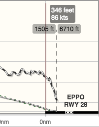
In the landing screenshots on the right and below we can see at a glance:
- The runway is depicted as a thick black line.
- The pilot landed on EPPO RWY 28.
- The touchdown was at 1506’. Till that point the runway is displayed to-scale.
- The runway remaining was 6710’.
- Over the threshold the aircraft (SR22T) was at MSL=346′ and airspeed of 86 KIAS.
- The short approach was stabilized: on the glidepath, with stable airspeed.
To display the Segment Info of the Final we clicked the ![]() icon in the segment list. Note the runway depiction in thick line on the lower-right. Click the picture below for details. To check the airspeed and altitude over the threshold, we dragged the time crosshair to the runway threshold.
icon in the segment list. Note the runway depiction in thick line on the lower-right. Click the picture below for details. To check the airspeed and altitude over the threshold, we dragged the time crosshair to the runway threshold.
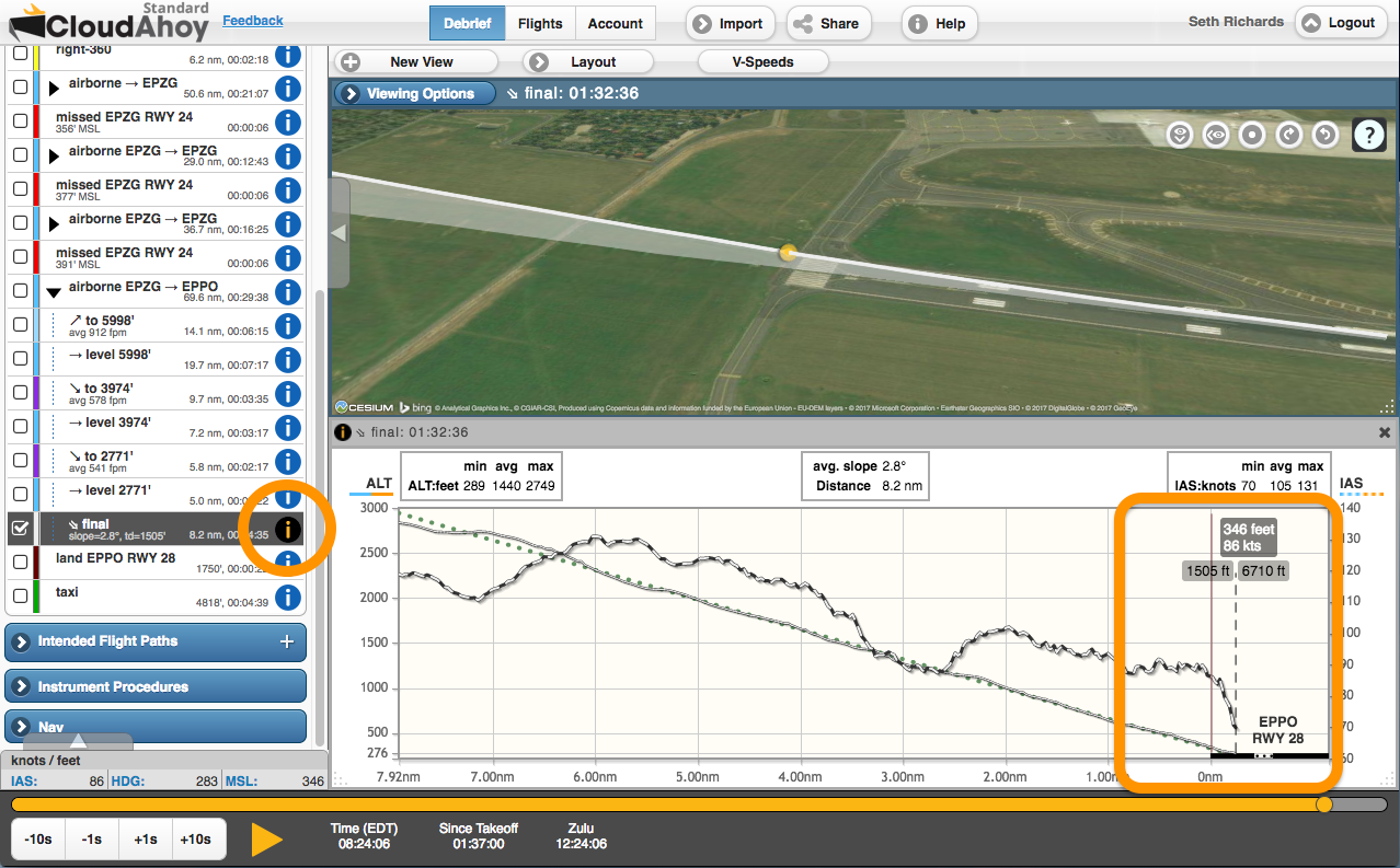
Along with the depiction of the runway, Segment Info graphs have been enhanced in these ways:
- The x-axis along shows the distance from the runway threshold, or in the case of a missed approach the point at which the missed approach started.
- The touchdown point is labeled with the distance from the threshold to touchdown, as well as the length of runway remaining after the touchdown.
- The airport and runway number are shown just above the runway.
Important
The accuracy of determining the location of the touchdown point depends on the data quality. An external GPS with good sky visibility will yield better accuracy than logging with your phone or tablet’s internal GPS. For best accuracy, import the flight data from your EFIS. See this.
As to GPS accuracy: When I bought my first iPad, I believed what I’d been told. I was told that an external antenna would improve GPS accuracy. So I spent $100, bought a Bad Elf, and used it. First off, it was in the way, secondly, it deteriorated GPS accuracy. Fair to Good was the best that I could get. Removing it improved accuracy to Good to Excellent. I threw away the Bad Elf. Maybe others had better lick.
In my experience, Bad Elf is a great GPS and greatly enhances accuracy vs. an internal GPS. I’ve used several models, and they were all excellent. I have not used the one that connects directly to the iPad though. Maybe that’s the one you had bad experience with?
The GPS should typically be placed/secured on the dash for optimum sky visibility. Seems to me that the external GPS that connects directly to the iPad may not have as good reception.
Kayak Jack, I have the same issue as you. When I use the Bad Elf device on my IPhone 7 it shows poor GPS on Cloudahoy, one day I forgot my Bad Elf device and just used the External GPS off my phone and when I went to debrief on Cloudahoy it showed “GPS Accuracy Excellent”. Wish I hadn’t spent so much money on the Bad Elf device.
Yes, Chuck, it was the direct plug in. It accomplished three things: wasted my money, got in the way, and worsened GPS reception. Who would’ve guessed that?
I usually practice short field take offs and landings. So, I have to control airspeed and remaining lift carefully to do it well. CloudAhoy tells me that, if I’m ever going to be any better tha jusr “well, okay”, I need to practice more.
I value that feedback. sigh
This looks to be a great addition to CloudAhoy, however, I am confused by the description a bit. You are referencing KIAS which would mean that you aren’t using GPS data, which would derive GS, not KIAS. Did I miss an integrated sensor that would provide KIAS? The same question for Altitude. This is all GPS-derived altitude data, correct? While altitude will certainly be more precise than GS vs KIAS, there is still a potential for the display in CloudAhoy to be off slightly from the aircraft instruments.
Hi Shane,
Re GS vs IAS – check this: https://help.cloudahoy.com/wind
The same applies to altitude: if you import the flight from an EFIS such as Garmin G1000, we can display both the indicated (baro) and the GPS altitudes. Otherwise we use the GPS altitude only. Note that we digitally enhance the GPS data, including altitude, so the MSL altitude displayed by CloudAhoy is, in most cases, more accurate than the raw data.
Chuck- You never answered the question regarding GPS-derived ground speed vs IAS. Even if you incorporated reported ASOS/ATIS winds at that moment of touchdown (and there is no means to determine monetary reported winds on a system that updates in one minute increments and reports online at much longer intervals) the wind speed and direction is still subject to inaccuracy. That means IAS as indicated by Cloud Ahoy is nothing more than a wild guess. In fact, if Cloud Ahoy could determine the exact winds at touchdown, then you would have something everyone would want. There are thousands of airports without weather reporting and even those with ASOS can be highly inaccurate since the ASOS sensor for obstruction safety is typically placed some distance from each runway touchdown point. If Cloud Ahoy knew something ASOS didn’t and one could obtain that information on final approach, then you could charge twice the price. Garbage in-garbage out..
Hmmm.. I just don’t get it!! I thought I could find where I was touching down on the runway and how much remaining. Alas, it seems as because I fly a gyroplane, this is NOT tracked by CloudAhoy! …or is it? Is there something that I change in one of the “parameters” etc so I could see this? I would REALLY like to see how short I’m landing and how much I’m using/remaing runway as I am going to OSHKOSH in a few days and landing on a 900 foot runway>>> Can you help me out??
Doug, could you please send a link to the flight to info@CloudAhoy.com?
Sent link