Flight Debriefing on iPad

Today I put in beta a pre-release version of iPad-based CloudAhoy debriefing.  Give it a try by logging in to beta from your Safari on your iPad.  Let me know how useful it is for you.

No, Apple/Google did not implement a Google Earth plugin in iOS.  That would be too easy.  Instead, when logging in on the iPad’s Safari, CloudAhoy debriefs the flight on Google Maps.  As the screenshot below shows, both Satellite and Terrain views are supported.

Because of the iPad’s small screen size, I added a button for closing the left panel, leaving only the Timeline shown. The same button is also available on all the desktop browsers, except Internet Explorer.

Obviously, the iPad’s implementation lacks the cool 3D features which you are used to in the Mac/Windows desktop version.  No cockpit view, no published 3D instrument approaches, and for now, no sectionals.

On the plus side, the iPad’s version can display the flight path on a terrain map.

BTW, the flight I chose for showing off the iPad’s debriefing was flown by me and a friend last Friday from P-town (that’s how the locals call Provincetown, MA).  P-town is a terrific destination, even this early in the season.

A Tale About the Tragic Collision of Two Planes

This blog entry is about the weirdest aerial accident I have ever read about.  I give below the abbreviated version, many details omitted for brevity.  But first, background.

In the last 100 years Argentina was blessed with a large number of enormously gifted musicians, people who touched the soul of an entire nation. Many were admired both in Argentina and worldwide, but none were admired and loved more than Carlos Gardel.  Gardel died in a plane accident on 24 June 1935 at the age of 44, but is still admired today, 77 years later.  Some say he actually sings better every passing day.  I agree.

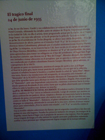
Last week my Spanish teacher Mariela and I visited the Gardel museum in Buenos Aires.  A corner of the museum was dedicated to the fatal accident.  The text (left) gave the official account of the tragedy, as follows.

Gardel’s plane, a three-engine F-31 flying from Bogotá to Cali, made a fueling stop at Medellín, where many admirers have been waiting for hours to see Gardel.  After fueling and a photo-op, the plane taxied to the south end of the runway, was cleared for takeoff by a waving of a white flag, and started a takeoff roll into the north (great footage at the bottom).  After 250m it suddenly turned right, got off the runway, continued 260m and collided with another plane which was preparing for takeoff, its engines running.  The two planes burst into flames, and 16 people including Gardel and the pilots of the two planes have died in the inferno.

The official account attributes this to an act of God: a sudden southwest gust of “6-7 Beaufort” (21-33 knots) pushed the F-31 off of the runway, and there was nothing that the pilot could have done to prevent the collision.  This account makes sense, plus it takes care of liability issues.

Back in the apartment, I googled the accident, and I bring below the alternative explanations.

The first evidence that the official account was incorrect is that the F-31’s landing gear tracks indicate that once it turned right it continued in a perfect curve of 30 degrees.  Had the pilot tried to correct for the wind, the track would zigzag.  Furthermore, some of the tracks disappear several hundred feet before the collision, and then reappear shortly before, indicating that the F-31 pilot had attempted to rotate.  The runway elevation in Medellín is 5000’.

There are also indications that the F-31 was too heavy even when it landed in Medellín, and probably off of the load-and-balance envelop after fueling and loading additional heavy cargo.  There are indications that the F-31 pilot was not proficient in the type of plane and perhaps rotated in ground effect and then stalled.

Why would the F-31 pilot turn in the direction of the other plane during takeoff?  Aha! There was a huge rivalry and animosity between the two companies operating the two planes, and specifically between the two pilots: Ernesto Samper Mendoza who flew the F-31 Gardel was on, and Hans Ulrich Thom who was the PIC of the other plane, getting ready for departure.  Several days before the accident Hans Ulrich Thom humiliated Ernesto Samper Mendoza by buzzing him – flying a few feet over his plane.  Perhaps Ernesto Samper Mendoza’s wanted to buzz his nemesis, which would be doubly humiliating because Ernesto Samper Mendoza was also flying a super-celebrity.

But wait, it gets even more interesting.  In an autopsy of Ernesto Samper Mendoza’s body, a bullet was found in his skull.  Where did the bullet come from?  Three theories: one is that after the crash Ernesto Samper Mendoza was still alive and shot himself to shorten his suffering.  Two is that there was a dispute onboard the F-31 during taking off, and a shot was fired which hit the pilot by mistake causing him to lose control.  The third theory is that the shot was fired by the other plane’s pilot, Hans Ulrich Thom, or  by his copilot whose body was found with a pistol.

We find it laughable that something like this could happen today between, say, Citation and Learjet pilots.  Aviation has become safer, if less romantic.

Listening to ATC on a Flight to Buenos Aires

A week ago my wife and I started a one-month vacation in Buenos Aires.   Flying there, we missed our connection in Dulles by 5 minutes.

Our United flight from Dulles left 24 hours later, on a stormy night.  The good news: our status was upgraded from “you’re on standby” to “passengers squeezed in row 35”.  The other good news: United has ATC audio in channel 9.  For a GA pilot this is pure joy, plus educational.  Here’s what I learned.

As we were taxing for takeoff, a thunderstorm with heavy rain passed over the airport.  ATC warned of microbursts.  It then cleared a plane for takeoff but the pilot refused to go.  Lots of planes were waiting in line, one of the parallel runways was closed, and there was a pressure to get everybody airborne, yet the pilot refused to roll.  ATC asked what his intentions are, and the pilot said that he wants to wait two minutes.  He requested ATC for more PIREPs.  The controller called both landing traffic and planes that have recently taken off, and relayed their data.  After 5 minutes the pilot of the number one plane agreed to go.  I learned a lesson in assertiveness, which was conducted in a very professional way.

After takeoff they switched us to Potomac departure.  Here again, there was a lot of give-and-take between pilots and ATC. Since the Heavy guys have radar, they kept providing PIREPs and requested vectors and altitudes to go around the storm system.  I was impressed by the close coop between the pilots and ATC, and by the level of professionalism.

The flight map in the plane’s seat had odd information.  My wife asked me what do they mean by “-50 knots headwind”: if the speed is negative, does it mean that it’s tailwind?  I did not know.  Later when we landed we had “-10 knots tailwind” (more on that below) and so it seems that the minus sign was for decoration only. Actually, maybe the speed was in miles/hour, not sure.

Over Argentina, I was surprised to find out that most of the comm was in Spanish.  I thought that if one pilot speaks English, everybody needs to switch to English.  Not so.  I speak a little Spanish and I could understand most of the dialogs.  The ATC, a female, was very courteous with the Spanish pilots, sometimes joking and laughing with them, but not so with the American pilots of several American planes on the frequency.  There were exchanges when the American pilots did not understand her, or she did not understand them.  I also thought that most of the American pilots were a bit rude to the controller, and talked fast as if they are still on US soil.  They did not make any noticeable effort to adopt their accent and speed to the situation.  I am assuming that the Spanish-speaking pilots did not understand much of the Americans’ exchanges either.

On our descent to Buenos Aires, flying south, ATC vectored us to land on runway 36.  The pilot came on the PR system and informed the passengers that we were instructed to land into the north, which he said is “unusual”, and therefore we will land later than planned.  His comment on the PR system cleared the confusion about the sign of the wind speed: ATC were vectoring him to land with tail wind.  Why?  Don’t know, maybe the ILS did not work on runway 18.

I was also surprised that they did not switch us to the tower frequency: the same controller kept talking to our pilot until after landing, when she switched him to ground.

Over Argentina it was a clear, perfect VFR day.

Buenos Aires is wonderful.  Totally wonderful.

CloudAhoy App release 1.7 — today

It’s in the app store as of today. This is a maintenance release, fixing three things:

– Better upload of data especially for iOS devices that are in Airplane Mode.  If you ever had a situation where flight was held in your iOS device for too long, it is now fixed.  Well, it’s fixed even if you never had the problem : )

– A recognition of Dual XGPS150 devices.  This is for display only, because even in pre-1.7 the data from Dual was used correctly.

– Devices left running for days.  This could happen in pre-1.7 when users started logging, and CloudAhoy waited patiently for them to takeoff, sometimes days.  Or it could happen if users have actually landed, but turned off auto-stop and never turned off the logging manually.

I plan to have the next app release in late April or early May.  It will have several new features, plus run in native mode on iPads.

The new Google Earth Plug-in is crashing on Macs

Sad Google

The dark side of Earth

A couple of weeks ago Google released their Google Earth version 6.2.  Unless you opted out, they upgraded your plug-in software automatically.

The previous version had several bugs that affected CloudAhoy users (and I, among many others, have reported and urged them to fix these bugs).  The bugs have been fixed, so 6.2 is good news.  But with the good news came some bad ones: the new version crashes a lot while running cockpit view animation.

I have received reports  from several users, all running on Macs.  Hey, are there Windows users out there who get this problem too?

When the problem happens, do like Google says: reload the page.  It helps… until the next crash.

I verified: this problem affects all the other camera movement applications that I tried, including Google’s own.  That’s  bad news, because if the bug were in CloudAhoy, I would have been able to fix it myself.

I found that if you get frequent crashes in one browser, switching to another is likely to help.  Today I failed to get the screenshot above while running in Safari – it worked beautifully for 15 minutes.  I switched to Firefox, and it crashed immediately.  Other days, it crashes a lot in Safari but not much in Firefox or Chrome.

I could not get the plugin to crash on Windows XP (both IE and Firefox).  Maybe because it runs a 32-bit plugin.

A bug can be both funny and annoying

Imagine yourself building a plane kit.  This is a huge endeavor in terms of the time, money and energy you devote to it.

At a certain point, the plane is ready to be tested, and you are ready to be your own plane’s test pilot.  Living in the US, you must register the plane with the FAA, which is not a trivial procedure.  After the registration process, you receive a tail number from the FAA, and anyone can type this tail number in the FAA registry and get information about the plane’s builder, namely you.

So far so good.  Now you register to CloudAhoy because you want to debrief your flights.  You enter your tail number, and CloudAhoy adds this tail number to the list of your planes, except, ooops, it lists someone else as the builder!  You have spent thousands of hours on building this plane, you registered it, and someone else is listed as the builder!  What is going on?

This happened yesterday to a CloudAhoy user.  The reason?  A bug in CloudAhoy. CloudAhoy incorrectly assumed that a given plane type is always manufactured by the same manufacturer.  For example, plane type 182R is always manufactured by Cessna, and S-76D is always manufactured by Sikorsky.   Obviously this is not the case with plane kits.  Turned out that a CloudAhoy user, call him A, entered his Lancair kit’s tail number, and CloudAhoy learned from the FAA’s registry that A is the manufacturer of that specific model of Lancair.  Then another user, B, entered his plane’s tail number, and the builder’s name was A.

Awfully sorry, B.  It will be fixed.  I can only imagine how annoying this could be to you.

Cockpit View — Released!

The Cockpit View is now released.

Select Cockpit View, click Play, and enjoy (click the “?” icon for more information).

Many thanks to all the beta users who have sent me encouraging emails, useful comments, and some “!” signs to spice the whole thing up!

A Steep Turn

A Steep Turn, Cockpit View

Cockpit View (at last!)


CloudAhoy’s cockpit view, including cockpit view animation, is now available in beta.

Be warned: it’s addictive.

To make it more fun, I now initialize the timeline’s slider to be the beginning of the takeoff roll (i.e., after the taxi to the runway).  So you can click Debrief, then set Cockpit POV (wow! you’re on the runway!), then click play, and watch the plane take off into the inviting blue horizon.

Many CloudAhoy users have asked in the past for a cockpit view.  If you are one of them, you probably received from me a polite email (recycled in part, to help save the planet) explaining why such a thing would be misleading because of all the unavoidable errors in calculating the displayed plane’s attitude.  That explanation was convincing, at least for me, and therefore I never implemented the mode.

Until now, that is.  I realize now that this mode is actually rather cool, and that the attitude calculation turned out to be pretty realistic (the link above explains some of the limitations of this mode).

What made me decide to do it?  I think it was a last-straw type of thing — last Friday I received yet another request to do it.  I was sitting at my computer at 2 PM, and I thought that I have a few hours to play with this before our friends come over for dinner.  Luckily Tani, my wife, was the designated cook that afternoon, so I could have several hours of hacking.  After dinner (excellant dinner BTW) I connected my laptop to the TV, and showed the hacked version to our guests, as an affordable replacement for a more robust form of entertainment such as a juggler on tightrope, or leopards jumping through rings of fire.  The guests liked it so much, that I decided to spend a week and do it right.  Soon I was doing physics on a legal pad, deriving the formulae.  Two days later I flew the Arrow, mostly for practicing Lazy Eights, but also to create a table of pitch angles in various configurations — as a way to calibrate the mathematical pitch model.

It’s still unclear to me in what ways will this mode aid in debriefing a flight.  But I am convinced that it’s as useful for debriefing as it is for just having fun.  As I was playing back some landings of mine, I did notice one from several months ago that was high above the glide slope.  I must have had four white PAPI lights in my face most of the way down on that landing. Maybe it was a case of being number 2 after a heavy military plane (my home airport is also an AFB), or maybe I was just being sloppy.  I could get the same information about the steep approach without the Cockpit POV of course.  In fact, turning the “further analysis” checkbox, CloudAhoy measures and reports the exact slope.  But I must admit that seeing the steep approach in the Cockpit POV mode gets the message deeper under one’s skin, more than the 5.7° slope number.

I kept playing back other flights, such as a flight that I flew with my son in valleys in the Rutland Vt. area, or a flight over Lake George.  It’s very entertaining, and looks pretty realistic albeit without a sound track.  One benefit of playing a flight in the cockpit’s POV is that you can click the 10x button and pretend that your humble GA plane is now a mighty F16.  Well, sort of.

I’ve had Google Earth crash on me at times when running this mode.  I think it crashed much more in Safari than in all the other browsers combined (Firefox, Chrome, IE).  Maybe it’s just my setup.

In a previous post I promised to write about Lazy Eights.  I never got to do it (and I’m not going to use the  pun that I was Lazy).  Next week we’re going on vacation, and I will be flying again in February.  Maybe I’ll write about the Lazy Eights then.

Soup University

I needed 4 instrument approaches for my IFR currency, which expired last month.  I flew three approaches last weekend, wearing foggles and with my friend Itay in the right seat.  That flight was mostly an exercise in controlling the autopilot on the 182’s G1000.  I’d give myself a B+ on my mastery of the autopilot: several times I thought that the autopilot was flying the approach, when in fact it was trying to hijack the plane, probably to Cuba, and I had to disable it.  I felt like Dave in “2001, a Space Odyssey”.

I flew three additional approaches today.  The ceiling was between 400’ to 800’, the constant pouring rain added strange sound effects, the windows were foggy, and my CFI John was in the right seat.  I wanted to take an Arrow for this flight, but it is grounded, so I flew a Warrior.

Although I had an iPad running ForeFlight with geo-referenced approach plates (and obviously running CloudAhoy as well), and although the Warrior has a Garmin 430, I decided not to use them for situational awareness, and use paper only.  There’s something pure and unspoiled about doing it that way.

Flying with John is always super educational. Flying with him, I think that on average I learn something new every 14 minutes; but in this flight the rate was even higher.  I started the engine and put it on 1000 RPM, then as I was dialing the frequencies in the radio John asked me if I looked at the engine’s RPM.  I looked, and it dropped to 900.  Ah, I said, I should use the friction lock to keep the throttle in place.  I reached out to push the throttle, but John suggested that instead I try carb heat.  I set carb heat and viola, in two seconds the RPM came back up to 1000.  I built ice in the carburetor! If I had flown the Arrow or the 182, I would not have learned this – both have fuel injection.

The first ILS approach was uneventful.  Not my best, nor my worst ever.  We broke out at 600’, and I could see the runway lights straight ahead although the runway was still in the mist.  Breaking out from a cloud base and seeing the runway lights straight ahead is probably the most rewarding price in aviation!  John asked me not to look outside and fly the remaining 200’ to the Decision Altitude looking only at the panel.  I flew the missed, and immediately got sucked back into the soup.  I sometimes wonder whether the term “soup” was coined in Boston, where the locals eat Clam Chowduh (myself, I don’t care much for this local delicacy).

On the second approach, which was a Localizer approach, John asked me if I ever flew partial panel in IMC.  No I didn’t, and today was therefore my first time.  John covered both the AI and the heading indicator, and my flight started to look like a drunken pilot’s.  John suggested that I use the 430’s compass-like display, and I did.  As I was trying to manage the situation, John kept asking me questions.  For example, if I wanted to use the magnetic compass, what type of errors should I be more concerned about: turning errors, or acceleration errors?  I figured that since I am not accelerating much in this flight, the correct answer would be turning errors.  No, said John.  He took the yoke and showed me what happens to the compass when the plane’s airspeed changes as it climbs or descends a mere 50’.  If you want to fly in IMC using the magnetic compass, said John, you better train for it.

I kept flying while John kept asking me a never-ending stream of questions.  What would be the next heading from ATC?  Where are we now relative to TAYUB?  What’s your primary gauge for pitch right now?  I think that in addition to teaching me, John was trying to saturate my brain, the way it would be in a real partial panel flight in IMC. Obviously, if you really lose your vacuum while in the soup, it’s a good enough reason to declare an emergency.

The third and last approach was ILS, still with the two gyros covered, and John suggested that I ask ATC for a no-gyro approach.  I have read about it once, but never practiced it, certainly not in IMC.  It was the coolest thing.  The controller acted in a very un-Bostonian manner, and worked with me with a lot of patience.  As I was flying, I said to John that the controller must be frustrated having to do this extra work, but John calmed me by saying that the controller probably appreciates the opportunity to practice this as well.  The idea in a no-gyro emergency is that instead of giving you vectors, the controller tells you when to start to turn and when to stop turning.  Looking at the CloudAhoy track above (with the published ILS approach overlay), indeed both of us learned during this approach.  Both he and I improved as the flight went on.

John then taught me another thing (I lost track of how many new things I learned).  Bend my leg so that the knee is higher and almost touches the yoke, rest my hand on my knee, and then fly the plane with my thumb and pointing finger.  This is so relaxing (assuming that the plane is well trimmed).  And is very precise as well, exactly the extra precision that the situation required.  I also used the pedals a lot for fine heading changes.

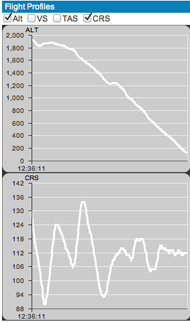
After intercepting the localizer, I started to chase the needles.  “Chasing the needles” is obviously a bad thing, something to be frown upon, but I think that without the vacuum instruments this is essentially what one does.  Looking at CloudAhoy’s altitude and course profiles below, it’s obvious that my chasing of the needles could have been done much better.

All in all, I was pretty happy with my performance, given the rust level and the workload.  CloudAhoy’s segments list, above on the left, shows that on my first ILS approach the missed was taken at 426’ (the minimums are 383’), and the missed on my LOC approach was taken at 721’ (the minimums are 720’).  The chasing of the needles on the third approach is shown in CloudAhoy’s profiles on the right.  While flying it, it did not feel as dramatic as it looks in the profiles, or as it looks in the ground track.  It’s one case where CloudAhoy has a sobering effect.  The two things that I am taking from this segment of the approach, thanks to CloudAhoy, are: (1) don’t turn more than 1/2 standard rate, (2) have patience: turn a little, stop the turn and see where the needle is going.
The rapid rate of teaching me new things did not end while taxing back to the ramp.  As I cleared the active, I pushed the VFR button on the transponder to set it to code 1200.  John asked me: supposed you pushed it by mistake, what’s the best way to put in the previous transponder code?  I did not know of a quick way but there is one (on that specific transponder): you long-click the button, and the old code comes up.  John said that it’s the same on the G1000.  Good to know!

But an even more important educational moment was 10 minutes earlier, when I was established on the localizer and Boston handed me over to the Bedford tower.  I repeated the instruction “6 November Delta, to tower”.  Before I clicked the frequency flip-flop to talk to the tower, John keyed the mike and said in his quite voice: thank you very much for your help.  The way he said it, it was clear that he actually meant it and was not only polite.  The controller said in a cheerful voice, you’re welcome sir.

What if your engine quits over New Hampshire?

Every pilot needs to have a bi-annual flight review (BFR).  A BFR must be taken either two years after the last BFR, or two years after the last checkride, whichever comes last. I had planned to start working on my Commercial rating in the summer of 2011, so that I will have the checkride in the fall and thus skip my BFR.  I’ve done it successfully two Novembers ago when I took my Instrument Rating checkride.

But this year my summer was spent on other things, I started my Commercial training in mid fall, and I will not have a checkride before the end of November.  So yesterday I had my BFR with John, plus I had an intro to Lazy Eights (which I will write about in a later post).

We did some airwork and then at about 4000’, somewhere between Lowell MA and Nashua NH, John pulled back the throttle and told me (wink wink) that the engine had just quit.

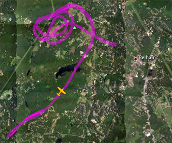
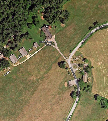
While trimming for best glide speed and pulling the prop RPM lever to reduce the prop drag, I searched for a suitable landing site.  At my altitude there was no hope of reaching the closest airport, at Nashua.  I identified a meadow in the forest and started gliding towards it.  John told me: did you know that this is actually an airport?  No, I did not know.  John pointed at some rectangular buildings and said that they are hangers.  As the ground got closer, I could actually identify a very short landing strip cut in the grass.

What new thing did I learn?  As I was circling the designated landing site, I had to decide in which direction to land.   So the obvious question, which John asked me, is what’s the wind direction.  I looked for obvious signs like smoke, but could not find any.  So I said, ahh, it is 250°.  I was cheating of course, using the wind direction at the departure airport.  John taught me how to find the wind direction while spiraling close to the ground. It’s quite trivial actually if you’re circling:  watch the lowered wing tip, and note where it is travelling faster or slower over the ground.  Should I have known it?  Yes.  Did I remember it as I was was losing altitude, preparing the plane for an emergency landing, and flying the plane?  No.

My first approach was not all that great – if I was actually landing, I would touch down farther from the runway end than I had wanted.  I pushed the throttle (aha!  The engine is working!  Music to my ears!), got back on the downwind, pulled the throttle back and executed another glide towards the runway, this time much better.

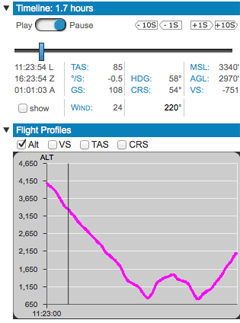
At home I debriefed my flight with CloudAhoy.  I defined a custom segment for the “engine loss”, and discovered two things: (1) on my approach I was 368’ AGL when I applied power.  I was actually on the downwind executing a short approach, and looking now at the terrain and the wind I realize that I would not have not made the runway.  I would have definitely survived the landing, but the plane might have been damaged.  (2) It took 4:07 minutes to glide from 4100’ to 825’ MSL, which is about 800 feet/minute.  I checked this against the Arrow’s POH (pg 5-31, Glide Time and Distance).  It’s about what the book has – so my glide was close to optimal.  That’s good to know.

I should start taking gliding in the summer.  The Hudson landing probably would not have been as successful had Sully  not been a skilled glider pilot.

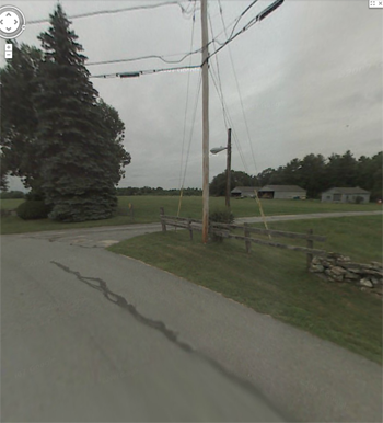
I then looked up the landing site in Google.  It’s called the Steck Farm, and is located on 146 Jeremy Hill Rd Pelham, NH.  I also looked at Google’s Street View: the entrance is very rustic, and does look quite like the highway exit to Logan Airport.  I tried to find more information about the farm, but could not find much other that the owner is Mr. John Steck, and the manager is Mr. Paul Steck, both of whom seem to live on the farm.  Is John the father of Paul?  Did the extended John and Paul families dine together on Thanksgiving in the farm?  Did they fly Aunt Suzy to the Thanksgiving dinner?  Turns out that the flight debriefing cannot answer all questions.